Lot 514
Price Realized: $120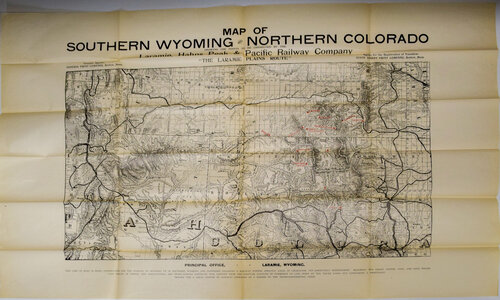 |
|
Lot: 514 Description: LARAMIE HAHNS PEAK & PACIFIC MAP Circa 1905 this was a pre-construction map that measures 21 x 34 with wide borders on thin stock. All connecting railroads shown an area from about 100 miles north of Cheyenne, Wyoming to a point south of Colorado Springs & Denver to Salt Lake City, Utah area. Slight tears at the folds otherwise another nice example. Minimum bid: $50 Price Realized: $120 |
)
)